
|
التغيرات الجيومورفولوجية المعاصرة لمجري فرع رشيد بمركز كفر الزيات باستخدام تقنيات الاستشعار عن بعد ونظم المعلومات الجغرافية
|
|
|
د. عبدالرازق بسيوني الكومي
|
|
|
قسم الجغرافيا كلية الاداب جامعة طنطا
|
|
|
abdelrazek.elkoumi@art.tanta.edu.eg
|
|
|
10
|
|
|
تكتسب دراسة التغيرات التي تصيب المجاري المائية، في أجزائها الدنيا لاسيما التي تجري عبر مناطق الإستقرار البشري أهمية كبيرة، في مجال الدراسات التطبيقية لاسيما الجيومورفولوجية منها، حيث تعد من المعايير التخطيطية للتنمية المستدامة في هذه المناطق وإدارة الموارد المتاحة بها، وحمايتها من الأخطار المتوقع حدوثها نتيجة التغيرات الجيومورفولوجية المرتبطة بتلك المجاري كتآكل الجوانب وتراجع الضفاف، وتغير خصائص المياه كماً وجودة، نتيجة لعمليات السحب المائي لأغراض الري و الشرب، أم لعمليات الصرف غير القانوني في هذه المجاري على مختلف انواعه الصحي والصناعي و الزراعي.
تمثل تقنيات الاستشعارعن بعد RS وتطبيقات نظم المعلومات الجغرافية GIS، وسيلة ناجحة في مجال رصد وتقييم التغيرات الجيومورفولوجية، سواء من حيث: تنوع البيانات التي تعتمد عليها، والدقة التي تتيحها في كشف التغيرchange detection الذي يصيب سطح الأرض بكل مكوناته Land Cover، لاسيما الخصائص الجيومورفولوجية لمجاري الأنهار، نتيجة لشدة التباين في الإنعكاس الكهرومغناطيسي Electromagnetic Reflectance للنطاقات الطيفية المختلفة، في مناطق التقاء المسطح المائي للمجري بما يجاوره من كتل يابسة ، وحساسيتها في تحديد التغيرات التي تصيب المياه نتيجة لاختلاطها بعناصر متباينة سواء كانت رواسب محمولة، أو مواد كيميائية مضافة بسبب عمليات الصرف فيها، وقد اعتمد على هذه التقنية في تقييم التغيرات الجيومورفولجية المعاصرة التي طرأت على مجري فرع رشيد، في جزئه الممتد بمحازاة مركز كفر الزيات بمحافظة الغربية، مع الإستعانة بتطبيقات نظم المعلومات الجغرافية في إجراء التحليلات المكانية لخصائص منطقة الدراسة.
|
|

|
Groundwater quality assessment of the shallow aquifer in Kafr Al-Zayat district (Egypt)
|
|
|
Alaa A. Masoud 1, Samir Z. Kamh 1, Hesham A. Ezzeldin 2, and Zeinab Sharaallah 1
|
|
|
1-Remote Sensing Laboratory, Geology department, Faculty of Science, Tanta University, Tanta 31527, Egypt. 2-Hydrogeochemistry department, Desert Research Center, Mataria, Cairo 11753, Egypt
|
|
|
alaa_masoud@science.tanta.edu.eg
|
|
|
15
|
|
|
Agricultural and industrial activities along with human practices have become common sources of the pressing groundwater pollution. Sustaining good groundwater quality is of global concern and is a goal of the world sustainable development agendas. In the present research, 28 samples from the groundwater shallow aquifer were collected from hand-dug wells in Kafr Al-Zayat district in April 2019. Physio-chemical and statistical analyses were performed to document the water quality status and their controlling factors. Elemental analysis was carried out using the Plasma Optical Emission Mass Spectrometer POEMS III (ICP, Thermo Jarrel elemental company, USA). Parameters included the in-situ measured total dissolved solids (TDS), pH, electrical conductivity, total alkalinity, total hardness, nitrate, in addition to 17 trace elements (Fe, Mn, Al, Ba, Bi, Cd, Co, Cr, Cu, Li, Mo, Ni, Pb, Zn, Sr, V, and Tl). Documented Water Quality Indexes (WQI) are evaluated to assess the water suitability for drinking and irrigation purposes. Correlation and factor analyses were carried out after the data were normalized to detect the factors that govern the groundwater evolution and their inter-relations. The geostatistical analyst implemented in ArcGIS was appraised for mapping the parameters using krigging technique where the quality of maps was also evaluated. The obtained results are compared to the local and world standards for drinking and domestic use. Results assure that monitoring and management practices should be augmented periodically to protect the water resources for the safe use that could ameliorate health hazards.
|
|

|
Environmental Modeling of the Geotechnical Hazards related to the Alluvial Soil in Alexandria and El Beheira Governorates, NW Nile Delta (Egypt)
|
|
|
Alaa A. Masoud 1, Mohamed M. El-Horiny 1, Amira Magdy Lohloh 1
|
|
|
1 Remote Sensing Laboratory, Geology department, Faculty of Science, Tanta University, Tanta 31527, Egypt.
|
|
|
alaa_masoud@science.tanta.edu.eg
|
|
|
17
|
|
|
Soil resources secure food and safe urban expansion. Sustainability of good quality soils urges periodic assessment of possible future natural and man-induced quality degradation. In this research, geostatistical mapping and statistical analysis were performed on 739 borehole data; 459 and 280 from Beheira and Alexandria governorate, respectively. A database of soil variables with depth was then produced included the grain size parameters, Atterberg Limits, unconfined and confind compression tests, chemical soil water analysis, and the sedimentary succession to a depth of 36 m from which the silty clay layer thickness was derived. Number of samples varied with the performed test. Descriptive statistics were appraised for clarifying the geotechnical variations among the studied districts of which 16 in Beheira and 7 in Alexandria. GIS - based geostatistical kriging with minimum error achieved was used for the spatial mapping of the geotechnical parameters in ArcGIS and analyzed to demarcate the at-risk zones in terms of their geotechnical hazards to focus on potential measures to prevent and ameliorate future building. Results are expected to help efficient decision-making process to set proper management zones and prevent geotechnical risks where measures in the design and construction stages can be decided for future expansions based on the district- and soil type-specific.
|
|

|
Competency assessment of Sentinel-2, ASTER, and EO-1 remote sensing data for soil salinity monitoring and modeling
|
|
|
Alaa A. Masoud1, Mohamed M. El-Horiny1, Katsuaki Koike2, Ahmed Gad3
|
|
|
1Remote Sensing Laboratory, Geology department, Faculty of Science, Tanta University, Tanta 31527, Egypt. Corresponding author's e-mail: alaa_masoud@science.tanta.edu.eg; 2 Department of Urban Management, Graduate School of Engineering, Kyoto University, 615-8540 Kyoto, Japan; 3 Geology Department, Faculty of Science, Ain Shams University, 11566, Cairo, Egypt
|
|
|
alaa_masoud@science.tanta.edu.eg
|
|
|
22
|
|
|
Soil salinization is critical in comprehensively corrupted land resources coexisted in arid to semi-arid climate with significant rate of evaporation. Monitoring, modeling, and analysis of the soil salinity provide key factors governing salinity enhancement when based on multisource and multispectral remote sensing imageries and advanced analytical techniques. In the present research, the compelling models of soil salinity monitored using the newly launched Multi-Spectral Instrument (MSI) onboard Sentinel-2, Advanced Spaceborne Thermal Emission and Reflection Radiometer (ASTER), Earth Observation satellite (EO-1), along with the digital elevation model (DEM) at 5m resolution of the Advanced Land Observation Satellite (ALOS) world 3D (AW3D), are evaluated. Marked as one of the most guaranteed zones in the Western Desert of Egypt for future agribusiness extensions due to good groundwater conditions and accessibility along with renowned historical medical and environmental tourism, Siwa Oasis is justified for a case study area. The uncontrolled groundwater withdrawal and overuse lead to ever-enhancing soil salinization and hence significant environmental degradation in Siwa. As a ground-truthing, a total of 43 soil samples was collected in September 2016 and their physical and chemical properties were determined. Pearson correlation was applied after data normalization to decipher interrelations between the measured soil electrical conductivity (EC) and various spectral parameters, such as band reflectance, rationing, combinations, and documented spectral indices. A salinity model based on Partial Least Squares Regression (PLSR) approach was then applied to evaluate and validate the models in various land covers and uses. Results approved the effectiveness and the great potential through the quick, time-and cost-effective and less effort regional density of sampling with reasonable accuracy comparable to traditional soil sampling methods. We claimed that the results of the study will be an effective tool in similar areas that suffer from salinization problems.
|
|

|
Geodatabase building and geotechnical modeling of the peat and organic sediments, North Nile Delta, Egypt
|
|
|
Alaa A. Masoud1, Samir Z. Kamh1, Aya M. A. AbuElata1, Mohamed E. Sakr2
|
|
|
1Remote Sensing Laboratory, Geology department, Faculty of Science, Tanta University, Tanta 31527, Egypt. E-mail: alaa_masoud@science.tanta.edu.eg 2 Department of Structural Engineering, Faculty of Engineering, Tanta University, Egypt
|
|
|
alaa_masoud@science.tanta.edu.eg
|
|
|
28
|
|
|
The nature and functions of peat and organic soils is critical to their safe use and urban expansion and predicting their geotechnical behavior in terms of settlement, shear strength and stability, with respect to time became a must. This urges a sound scientific understanding and expanding knowledge base and calls for a reliable characterization of their spatial extent and geotechnical properties and mechanical behavior and subsequently, the devising of suitable design parameters and construction techniques for dealing with these marginal soils. In the present research, 1184 borehole soil mechanics report were investigated (619 in Kafr Al-Sheikh, 512 in Dakahlia, and 53 in Damietta), and a geodatabase was generated. Geostatistical mapping and statistical analysis were performed on soil variables varying with depths such as the grain size parameters, Atterberg Limits, unconfined and confined compression tests, chemical soil water analysis, and the sedimentary succession to a depth of 15 m from which the peat and organic soils were detected in 333 borehole and characterized (e.g., surface top and bottom, average depth and thickness, and pressure, etc). Out of the 333 boreholes, the unified soil classification system (USCS) data was available for samples from 255 boreholes (218 CH, 6 CL, and 31 OH). Number of samples varied with the performed test. Descriptive statistics were appraised for clarifying the geotechnical variations among the studied districts (10 in Dakahlia, 10 in Kafr Al-Sheikh, and 7 in Damietta). ArcGIS - based geostatistical kriging with minimum error achieved was used for the spatial mapping, analyzed to demarcate the at-risk zones in terms of their geotechnical hazards, and to focus on potential measures to prevent and ameliorate future failure of construction due to the problematic soils. Results are expected to help efficient decision-making process to set proper management zones and prevent geotechnical risks where measures in the design and construction stages can be decided for future expansions based on the district- and soil type-specific.
|
|
|
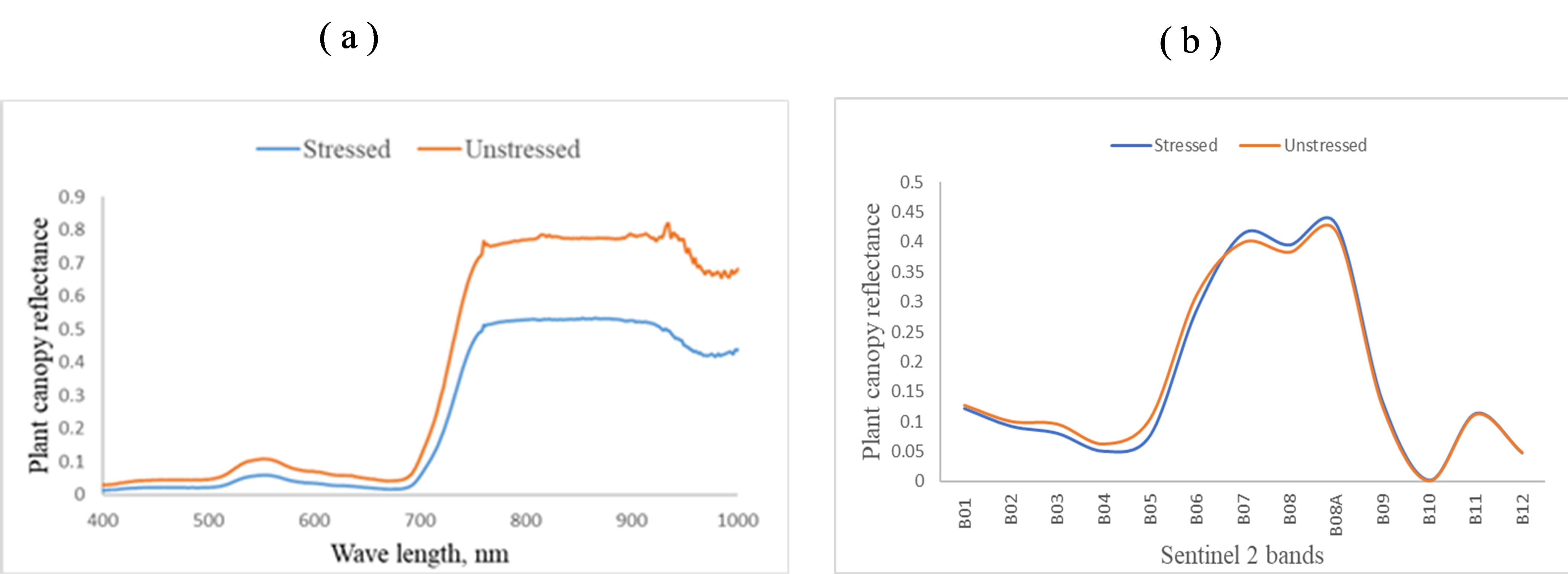
Hyperspectral vegetation indices for the remote assessment of heavy metals stress detection in cereal crops
|
|
|
M. M. Amer, A. M. Helal
|
|
|
Associate professor of agricultural engineering
|
|
|
mayieamer@yahoo.com
|
|
|
37
|
|
|
Regional-level information on metals pollution in agro-systems is essential for food security because excessive levels of metals in crops may pose risks to animals and humans. However, collecting this information over large areas is inherently costly. This paper investigates the possibility of applying multitemporal Sentinel-2 satellite images to detect heavy metals-induced stress (i.e., Mn and Fe stress) in wheat crops in the Nile Delta, El – Gharbia Governorate (lat. 31º 06.620ʹ N, long 31º 03.665ʹ E), Egypt. For this purpose, we compared Sentinel-2 image acquired in 2019 with in situ measured hyper-spectral data, and metals concentrations in the plant samples collected from fields in the study area. The present study was led on the experimental site, during the wheat cropping season (2018/2019) of the Egyptian wheat crop (Triticum aestivum L.). The results indicate that: (1)Vegetation indices (VIs) related to red edge bands were referred to as the sensitive indicators for screening stressed wheat from unstressed wheat, (2)The Infrared Percentage Vegetation Index (IPVI), Modified Simple Ratio (MSR), Normalized Difference Vegetation Index (NDVI), Soil Adjusted Vegetation Index (SAVI), and Simple Ratio (SR) indices derived from multi-temporal Sentinel-2 images were good indicators for screening stressed wheat from unstressed wheat with a high R2 > 0.5.
This study suggests that regional heavy metal stress may be accurately detected using multi-temporal Sentinel-2 images, using VIs sensitive to the heavy metals content of crops.
|
|

|
الحرارة المتجمعة وتآثيرها على زراعة بعض محاصيل الفاكهة بين فرعى دمياط ورشيد دراسة تطبيقية بإستخدام نظم المعلومات الجغرافية
|
|
|
كرولس عاطف نعيم لبيب
|
|
|
معيد بقسم الجغرافيا ونظم المعلومات الجغرافية كلية الآداب جامعة طنطا
|
|
|
kerolosatef94@gmail.com
|
|
|
47
|
|
|
الحرارة المتجمعة وتآثيرها على زراعة بعض محاصيل الفاكهة بين فرعى دمياط ورشيد دراسة تطبيقية بإستخدام نظم المعلومات الجغرافية
كرولس عاطف نعيم لبيب (1)
الملخص :-
يعد المناخ أحد أهم المتغيرات البيئية التى تؤثر فى نمو وزراعة محاصيل الفاكهة ، ويعد عنصر درجة الحرارة من أهمها ، حيث أن لكل محصول زراعى حد أدنى وحد أقصى من درجات الحرارة التى إذا ما تجاوزها هبوطاً أو صعوداً فإنة يتعرض للموت والهلاك ، ولكل محصول درجة حرارة مثلى عندها ينمو ويزدهر ويقوم بوظائفه على الوجة الأمثل
بالإضافة إلى الحد الأدنى لدرجة حرارة النمو يتطلب نضوج كل محصول زراعى عدداً من الوحدات اليومية للحرارة المتجمعة والتى ينبغى ان تتجمع أثناء فصل نموه فوق درجة الحد الأدنى لنموه ، حيث أنه لا يمكن لأى نبات أن يكمل دورة حياته على الوجه الأمثل من ناحية النمو الخضرى ، الزهرى ، والثمرى ، إلا إذا حصل على كمية معينة من الحرارة أثناء فصل النمو .
ومن ثم فإنه عند إختيار صنف من الفاكهة فلابد من حساب الوحدات الحرارية الفعالة الكلية لهذا الصنف و إختيار المنطقة التى تتوافر بها هذه الوحدات ويطلق عليها وحدات حرارية (Heat Units ) وهى عبارة عن مجموع الوحدات الحرارية السائدة بالمنطقة إعتباراً من تفتح البراعم وحتى جمع المحصول.
ومن هنا كانت فكرة هذا البحث ، حيث إتضح للباحث أهمية دراسة الحرارة المتجمعة وآثرها على نمو ونضوج محاصيل الفاكهة بين فرعى دمياط ورشيد ، وذلك تحقيقا للفائدة فى التخطيط الزراعى ويهدف البحث إلى توزيع درجات الحرارة المتجمعة ، و تصنيف منطقة الدراسة إلى نطاقات حسب مستويات درجات الحراة المتجمعة ، وتحديد النطاق الأنسب من حيث توافر درجات الحرارة المتجمعة اللازمة لمحاصيل الفاكهة بالتطبيق على محاصيل الموالح .
ــــــــــــــــــــــــــــــــــــــــــــــــــــــــــــــــ
( 1) معيد بقسم الجغرافيا ونظم المعلومات الجغرافية ، كلية الآداب ، جامعة طنطا ، تخصص دقيق : مناخ تطبيقى ، ت : 01285006803 ، البريد الإلكترونى kerolosatef94@gmail.com
|
|

|
تقلبات الأمطار الحالية في شمال غرب مصر
|
|
|
د. محمد زاكي سالم
|
|
|
المكتب الفني لرئيس قطاع شئون الرصد والاتصالات والمعلومات والأملاك - وزارة الموارد المائية والري - مصر
|
|
|
m_zakysalem85@yahoo.com
|
|
|
60
|
|
|
تُـعد دراسة التغيرات المنـُاخية من الموضوعات الهامة في الوقت الراهن، وقد تأثرت المناطق الشمالية الغربية من مصر بتغيرات درجات الحرارة وتقلبات هطول الأمطار على مدار الوقت في العقود الستة الماضية. ونظراً لوقوعها ضمن الأراضي الجافة وشبه الجافة وتعرضها للجفاف المتكرر الناتج عن التذبذب الشديد في كمية الأمطار الساقطة سنوياً بالإضافة إلى التغير في نمط الأمطار وفاعليته وهذا يؤثر بشكل كبير على الإنتاجية الزراعية وعلى النشاط الرعوي. ويعد النشاط الزراعي في منطقة الدراسة هبة الأمطار فالزراعة في معظمها مطرية. تم جمع البيانات الشهرية لدرجات الحرارة وهطول الأمطار في سبع محطات للأرصاد الجوية منتشرة من الإسكندرية إلى الحدود مع ليبيا فى الفترة من 1975 حتى 2018 م، من أجل تحقيق الهدف من الدراسة وهو دراسة تقلبات الأمطار الحالية باستخدام أساليب إحصائية متنوعة ومناسبة لتحديد الإتجاه العام للأمطار (Trend) ومعامل التذبذب (Variability Index)، ومؤشر الأمطار (Rainfall Index) لمعرفة دورات الجفاف، وكثافة الأمطار وفصليتها، ثم حساب فاعلية الأمطار للوقوف على خصائص الأمطار في منطقة الدراسة. وكانت اتجاهات هطول الأمطار سلبية في معظمها، أو لا توجد اتجاهات، ولكنها توقفت بسبب الشذوذ متعدد السنوات خلال فترة الدراسة. وقد لوحظ أيضًا أن كمية الأمطار وتوزيعها قد أصبحا غير متوقعين. سيؤدي تغير المناخ إلى تدهور الغطاء النباتي في منطقة الدراسة مما يسبب الرعي الجائر يليها التصحر. وتتأثر تقلبات الأمطار في منطقة الدراسة بالاختلاف الكبير لحجم التغير المناخي في شمال غرب مصر.
|
|

|
التحليل المكانى للمواقع الآثرية فى محافظة الغربية بإستخدام نظم المعلومات الجغرافية
|
|
|
1- الأستاذ الدكتور مسعد سلامة مندور ، أستاذ الجغرافيا الطبيعية ، بقسم الجغرافيا ونظم المعلومات الجغرافية ، كلية الآداب ، جامعة المنصورة . 2- الأستاذة رباب عبد الحكيم إبراهيم ، معيدة بقسم الجغرافيا ونظم المعلومات الجغرافية ، كلية الآداب ، جامعة المنصورة .
|
|
|
معيدة بقسم الجغرافيا
|
|
|
rabababdelhakim@mans.edu.eg
|
|
|
73
|
|
|
تعد نظم المعلومات الجغرافية من الأنظمة التى تستخدم فى جمع وصيانة وتخزين وتحليل وتوزيع البيانات والمعلومات المكانية ، وإخراج خرائط رقمية للمواقع الآثرية والتى يمكن أن تساهم فى الحفاظ على المناطق الأثرية أو تطويرها . وتقع محافظة الغربية فى وسط الدلتا المصرية بين فرعى دمياط شرقا ًورشيد غربا ً ، ويحدها محافظة الدقهلية شرقا ً ومحافظة البحيرة غربا ً ، ومحافظة كفر الشيخ وجزء من محافظة الدقهلية شمالا ً ومحافظة المنوفية جنوبا ً بين دائرتى عرض 36 ً 30 ْ ،39 ً 30 ْ شمالا ً ، وبين خطى طول 45 ً 30 ْ ، 15 ً 31 ْ شرقا ً .
ويهدف البحث إلى إنشاء خريطة رقمية للمواقع الآثرية موضحا ً عليها أهم المواقع وتصنيفها بحسب تاريخها ونوعها ، ثم تحليل العلاقات المكانية لكل منها وصولا ً إلى عمليات التخطيط السياحى لهذه المواقع ، ويمكن لهذه الخرائط الرقمية المساهمة فى خدمة صناع القرار وتصنيفها سياحيا ً ، وتنميتها داخليا ً وخارجيا ً .
ولتحقيق أهداف البحث تم تقسيمه إلى ثلاثة نقاط رئيسية الأولى هى تصنيف المواقع الآثرية فى محافظة الغربية ، والثانية هى الخريطة الرقمية للمواقع الآثرية ، والثالثة التطوير السياحى للمواقع الآثرية بالمحافظة ، وينتهى البحث بخاتمة تتضمن أهم النتائج والتوصيات .
|
|

|
Tracing the Recent environmental changes in Edku Lake, northern Egypt via microfossils
|
|
|
Abdelfattah ZALAT, Ali SOLIMAN
|
|
|
قسم الجيولوجيا - كلية العلوم - جامعة طنطا
|
|
|
ali.soliman@science.tanta.edu.eg
|
|
|
75
|
|
|
A total of 138 subsurface samples obtained from five short cores recovered from Lake Edku reflects the environmental history through the last millennia. Fossil diatoms and non-pollen palynomorphs assemblages were dominant in the investigated sediments and used to assess the environmental changes of the lake during the past 1000 years. Detailed diatom investigation indicates a considerable variation in the composition and distribution of 115 diatom species among the studied cores. At the same set of samples, palynological analysis has revealed the presence of terrestrial and marine organic-walled microfossils including microforaminiferal test linings, zoological remains, algal remains, fungal spores and mandibles. Multivariate statistical analysis included hierarchical ascending clustering and Detrended correspondence analyses were used to identify ecological diatom groups.
The composition and general distribution pattern of the microfossils in the investigated samples with the recognized ecological groups indicated changes in the water salinity, lake level, pH and trophic state of the lake, which in turn may related to eustatic sea level fluctuations, human activities and climatic changes during the late Holocene. The predominance of the epiphytic taxa explained lowering water level and developed macrophytes in particular at the southern and eastern areas. The common occurrence of the alkaliphilous benthic species with considerable numbers of the alkalibiontic forms reflects warm, alkaline, shallow water habitats. Moreover, both the sea water intrusion and treated/untreated polluted fresh water drained into the Edku Lake show a major role in the diatom composition, distribution and dominant species.
|
|
|
Evaluation of Satellite-based Rainfall Estimates Over the Eastern Nile Basin
|
|
|
Dena H. Zamzam1, Tamer A. Gado2, and Bakenaz A. Zeidan 3
|
|
|
1,2,3Dept. of Irrigation and Hydraulics Engineering, Faculty of Engineering, Tanta University, Egypt.
|
|
|
dena.zamzam@f-eng.tanta.edu.eg
|
|
|
121
|
|
|
Water resources planning and management is generally based on precipitation data which is the most important parameter of the water cycle characterization. In the Nile Basin, conventional rain gauges are normally sparse; and therefore, satellite-based rainfall estimates have become vital for hydrometeorological studies in the basin. However, estimates from satellite rainfall products are prone to bias and need to be validated in this region. In this study, two widely used high resolution satellite rainfall products (TRMM-3B42 V7 and PERSIANN-CDR) are evaluated against ground daily observations from 25 stations in the Eastern Nile Basin during the period of 2006-2010. Moreover, satellite-based rainfall estimates from both products are adjusted by three bias correction methods: Linear scaling (LS), local intensity scaling (LOCI), and quantile mapping (QM). The evaluation process is based on several standard statistical criteria in order to assess the ability of both satellite products and bias correction methods to capture rainfall characteristics in this area. The results show that rainfall estimates from both products have a reliable agreement with ground measurements in detecting rainfall events, especially in the wet season. Overall, the performance of TRMM-3B42 V7 is better than that of PERSIANN-CDR. Regarding to bias correction, the QM is the best in adjusting rainfall extremes. The findings of this study show the importance of the evaluation and adjustment of different satellite rainfall products in order to be used for various hydrological applications in the Eastern Nile Basin.
|
|

|
Bias correction of Daily satellite-based Rainfall Estimates over Egypt
|
|
|
Basma A. Shalaby1, Tamer A. Gado2, and I.M.H Rashwan3
|
|
|
1,2,3Dept. of Irrigation and Hydraulics Engineering, Faculty of Engineering, Tanta University, Egypt.
|
|
|
engbasma2016@yahoo.com
|
|
|
122
|
|
|
Ground precipitation estimates face obstacles and limitations in many regions in the world, where gauge stations are sparse or even nonexistent. Thus, it is necessary to find reliable sources such as satellite-based precipitation products which provide uninterrupted precipitation time series with global coverage. Yet, the hydrological applications of satellite-based precipitation data are rather limited due to its biased estimate. In this paper, satellite precipitation data from PERSIANN-CDR (Precipitation Estimation from Remotely Sensed Information using Artificial Neural Networks-Climate Data Record) was biase-corrected against daily gauged data of 25 stations in Egypt for the period of
1999-2014. Three bias correction methods were used: linear scaling (LS), local intensity scaling (LOCI), and quantile mapping (QM). Their effectiveness of correcting the PERSIANN-CDR data to reproduce the characteristics of precipitation over Egypt was evaluated by using standard statistical and graphical tools. The results indicated that the performance of PERSIANN-CDR is quite well in detecting the occurrence of precipitation events, however, in the amount of precipitation,there are large differences with the observed values in all stations. The three bias correction methods perform reasonably well in reducing biases from such estimates. Importantly, the QM is more accurate than the other two methods in adjusting precipitation extremes stem from PERSIANN-CDR. The analyses suggest that further research is essential to evaluate different satellite precipitation products and bias correction methods in order to come up with the optimal procedure for satellite precipitation estimates over Egypt.
|
|
|
Environmental history and Climate variabilities over the last 2500 years in middle Egypt derived from diatom record of Qarun Lake sediments
|
|
|
Abdelfattah Zalat1, Leszek Marks2, Fabian Welc3, Jerzy Nitychoruk4
|
|
|
1 Tanta University, Faculty of Science, Geology Department, Tanta, Egypt; e-mail: abzalat@science.tanta.edu.eg (corresponding author) 2Faculty of Geology, University of Warsaw, 01-926 Warsaw, Poland; e-mail: leszek.marks@uw.edu.pl 3 Institute of Archaeology, Cardinal Stefan Wyszynski University, 01-938 Warsaw, Poland ; e-mail: f.welc@uksw.edu.pl 4 Faculty of Economic and Technical Sciences, Pope John Paul II State Higher School of Education in Biała Podlaska, 21-500 Biała Podlaska, Poland; e-mail: jerzy.nitychoruk@pswbp.pl,
|
|
|
abzalat@science.tanta.edu.eg
|
|
|
203
|
|
|
Diatoms are an effective bioindicator for environmental and climate changes due to their sensitivity to different ecological factors. Reconstruction of the environment and past climate changes can be estimated from changes in species abundance and composition within a sediment core, as the ecological requirements are well known for several ‘indicator’ species. A comprehensive examination of diatoms from four short cores drilled in Qarun Lake at the north of Faiyum Oasis was carried out to reconstruct the environmental history and climate change over the past 2500 years. Diatom analysis of the investigated cores sediments reflected marked fluctuations in the ecological status of the lake, including changes in lake water levels and a series of oscillations between fresh and brackish water episodes. The distribution pattern, the relative abundance and species composition of the recorded diatom assemblages, besides, the multivariate statistical analyses distinguished fourteen diatom ecological groups, which indicate the environmental changes of the lake that mainly related to climatic variabilities and anthropogenic effects during the past two millennia. The diatom record indicated five phases of lake’s history, which were signified by fluctuations between relatively deep freshwater lake during humid-wet periods, and shallow brackish water conditions that prevailed in warm-arid episodes. Rapid alteration in the Qarun Lake has occurred during the last century, whereas the lake has changed from highly brackish water to saline, which was distinctive in the last phase of lake evolution. A great abundance of mesohalobous and polyhalobous diatom taxa at the top parts of the investigated cores indicates a significant rise in salinity of the lake due to a great reduction of freshwater that enters the lake, as well as an increased evaporation process due to a recent warm dry climate. The high trophic state of the water reflects increased human activities in the youngest history of the lake.
|
|

|
Bias correction of regional climate model outputs for climate change impact assessment in Egypt
|
|
|
Mahmoud B. Mohameden1, Tamer A. Gado2, and I.M.H. Rashwan3
|
|
|
3Dept. of Irrigation and Hydraulics Engineering, Faculty of Engineering, Tanta University
|
|
|
mahmoud.basher@f-eng.tanta.edu.eg
|
|
|
242
|
|
|
Biases and systematic errors in regional climate models (RCMs) hinder their direct use in the study of different hydrological processes (e.g., precipitation and evapotranspiration). Therefore, bias correction of RCMs simulation is requisite before using their outputs in hydrological modeling. This paper aims to correct daily average, maximum, and minimum temperature of RCM against observed temperature data of 26 stations in Egypt with the five-year control period (2001 – 2005). Furthermore, the performances of four different bias correction methods are assessed and compared: linear scaling, variance scaling, empirical quantile mapping, and distribution mapping. The results show that the performances of all methods are reasonably well in correcting RCM simulated temperature data. The variance scaling is the best method in correcting different statistical characteristics of temperature. Consequently, this method is applied to correct temperature of representative concentration pathway scenario (RCP2.6) for the period 2070 to 2100 in order to have a comprehensive assessment of climate change impacts on different hydrometeorological processes in Egypt.
|
|

|
Geoenvironmental classification of geo-archaeological sites
|
|
|
Prof.Hani Mostafa
|
|
|
faculty of science, Menofia University
|
|
|
hanibrahim2000@yahoo.com
|
|
|
1351
|
|
|
Archaeological sites are the most visible aspects of our cultural heritage. These monuments often of stone construction are University threatened by pollution, urbanization, public access, and geological hazards such as rock falls, salt weathering, landslides, earthquakes and flooding.
According to monuments geomorphological situations, they may be classified into four suggested categories; firstly, monuments were erected in relatively flat low-lying areas the most effective common hazard to this category is salt weathering due to the uprising of salty sun surface water to the lower parts of the monuments. Also these category may be subjected to flooding, moving sand , and dust storms as well as human interference. Ex. Islamic monuments old Cairo, Egypt.; secondly, monuments were built on hilltop slopes This category could threatened by slope instability. Ex. Castles and fortresses; thirdly, ornaments found at the cliff footings this category may be suffered mainly due to the hazards of rock falls coming from higher cracked cliffs overlooking them .Ex. Hatshepsut Temple, Luxor, Egypt. and fourthly, those within natural and/or man-made underground or surface openings, this category may suffered from ceiling instability and increasing humidity which give rise to all sorts of problems ranging from opening collapse to damage two sculptures and wall decorations Ex. Syrabium excavation, Saqqara, Egypt,.
According to this suggested classification, prediction of geo-environmental hazards and restoration for each category as well as Geographic Information System could be possible. could be possible.
|
|

|
Bias correction of regional climate model simulations of rainfall in Egypt
|
|
|
Tamer A. Gado, Rufayda M. El-Hagrsy, and I.M.H. Rashwan
|
|
|
Faculty of Engineering, Tanta University
|
|
|
tamer.gado@f-eng.tanta.edu.eg
|
|
|
1366
|
|
|
An accurate estimation of extreme rainfall events is important for water resources management. Recently, the intensity and frequency of rainfall extreme events have significantly altered globally due to climate change. Regional climate models (RCMs) have become very important tools to describe and predict different hydrological processes such as precipitation. However, their applications in climate change studies are challenging due to inherently systematic errors. This work, therefore, aims to correct RCM simulations of precipitation with reference to observed daily rainfall data of 15 stations in Egypt within the control period (1995 – 2005). Furthermore, the performances of three commonly used bias correction methods of rainfall are evaluated: linear scaling, local intensity scaling, and empirical quantile mapping. The results show that RCM simulated rainfall data are significantly biased from observed data at most stations in Egypt, and the performances of the three methods are reasonably well in correcting these simulations. Although all methods can correct the mean values, their abilities to capture other statistical properties of rainfall data (e.g., standard deviation, and percentiles) are quite different and depend on the region. The analyses suggest that further investigation is essential to evaluate the IPCC climate change scenarios to have a comprehensive assessment of climate change impacts on rainfall in Egypt for developing adaptation and mitigation measures.
|
|

|
Quantitative estimation of different evapotranspiration methods under the effect of climate change in Egypt
|
|
|
Marwan A. ELareiny, Mohamed S. Rashie, Ahmed I. Alwan, Mahmoud O. saleh, Mahmoud B. Mohameden*, Tamer A. Gado
|
|
|
Dept. of Irrigation and Hydraulics Engineering, Faculty of Engineering, Tanta University
|
|
|
mahmoud.basher@f-eng.tanta.edu.eg
|
|
|
1373
|
|
|
An accurate estimation of evapotranspiration is important for water resources management. Recently, regional climate models (RCMs) have become very important tools to describe and predict different hydrological processes (e.g., precipitation and evapotranspiration) in the context of climate change. In this study, four different methods are applied to calculate the potential evapotranspiration (ETo): Penman-Monteith, Hargreaves, Blaney-Criddle, and Hamon, by using historical meteorological data of 26 stations across Egypt with the five-year control period (2001–2005). Moreover, the potential evapotranspiration is estimated under the effect of representative concentration pathways scenario (RCP4.5) for two different future periods: (2020–2030) and (2070–2080). The results show that the potential evapotranspiration will significantly increase throughout the country under the climate change scenario (RCP4.5) for all considered methods. The Hargreaves equation reported the highest ETo values in all regions, while the Blaney-Criddle equation had the lowest ETo values for both future periods, there is no significance differences between Penman-Monteith and Blaney-Criddle
|
|
|